Grading Plans and As-Built Plans
Your value oriented civil engineering professionals for Ottawa and the surrounding areas.
If you’re looking to take on any land improvement project or new build; whether it’s a new shop or garage, or an addition to your house, chances are that you will need a building permit. One common requirement to get a building permit is a Grading Plan or a Grading and Drainage Plan. This plan is typically prepared by professional, licensed, engineer.
The Shade Group Difference
Shade Group sets itself from the competition in a few ways:
- All of our plans are completed from start to finish by an engineer. From the initial field work (if required) to the drafting and the design, our plans are prepared by a professional. Not a junior staff member, not a technician - a professional, licensed engineer.
- All of our plans are prepared in consultation with our construction department. This key value added service could save you thousands during construction, as our construction team can pickup on construction challenges (and solutions!) that are often missed by teams who are focused solely on design. The integration with our construction team sets us apart and sets us ahead of the competition!
- Our Grading and Drainage Plans are focussed on constructability - not just passing the permitting stage. Construction is the most expensive part of any project. Spending a little more time and money upfront on good, optimized design, can lead to thousands in savings during the most expensive part of the project! Don't undervalue the design stage!
Did you know...
It is common industry practice to have junior staff members or technicians prepare a grading plan; and the only involvement from a licensed professional may be a final review before it's stamped.
Oftentimes, the final review is limited to "does it work". The answer may be yes - but that doesn't mean it's the most cost effective solution.
That is not the case at Shade Group. All of our work is done by a licensed professional engineer; from start to finish.
Did you know that design of grading and drainage isn't black and white? There is rarely only one solution! But oftentimes, there are better solutions than others. Unfortunately, in the effort of saving cost, most companies won't look at multiple approaches or multiple solutions to determine which one is best. They focus on providing a solution that works - even if it isn't the best option from a construction standpoint.
Oftentimes - those better solutions are only known by those with the knowledge and experience to understand "cause and effect"; and with experience to understand that certain designs lend themselves to (expensive) construction challenges.
We often see plans that have been prepared with no consideration for future maintenance! You will need to mow the property - and having a Grading and Drainage Plan set with steep slopes could make that a nightmare.
At Shade Group - we're focused on finding the optimized design for your project. That includes:
- Consideration for construction. Does the plan has a design that is difficult to implement during construction (or sometimes even impossible).
- What about maintenance? You'll need to mow the grass. The proposed grading should factor that in! Mowing a steep incline can be difficult and dangerous - and adjusting the grading (or considering the implementation of retaining walls) can seriously improve your experience with your landscaping.
We understand that just because you can draw it that way (and it may even be accepted that way by the permitting agency) - doesn't mean it can actually be built as drawn!
Why do I need a Grading Plan?
When an engineering prepares a grading plan - they're looking at the topography of the land, both on your property and the neighbouring property. The primary purpose of a Grading and Drainage Plan is to ensure that any proposed changes do not negatively impact either the subject property, or the surrounding properties.
Questions an engineer is looking to address when they design may include:
- Does the construction block water from either leaving or coming on to the property?
- Is the construction proposed at an appropriate elevation so as not to get flooded?
- Is the construction going to lead to flooding on the neighbouring properties?
The answer to these and many other questions are what need to be addressed through the development of a Grading Plan!
The City of Ottawa may require a Grading Plan for the following:
- If the proposed construction may adversely affect the existing drainage;
- The proposed new building, addition, or accessory structure is greater than 592 sq ft (55 sq m);
- The proposed structure is within 4 feet (1.2m) of the property line;
- Installation of a pool within 4 ft (1.2m) of a property line.
The Design Process
The development of our Grading and Drainage Plans is done in three stages.
Step #1. Collect Field Data
There are certain pieces of information we require in order to prepare a proper Grading Plan. The first step is topographic information; information that shows the varying elevations across your property. As a general best practice, this information should be current to within the past 1-3 years. It cannot have been collected prior to any changes to your property. Changes may include anything from landscaping to new additions, sheds, garages, etc. Typically, we would recommend getting a new topographic survey for each new development project.
A topographic survey can be conducted by a professional Land Surveyor, and this is often the most cost effective approach if you require additional surveying services such as Registered Land Surveys. However, if you have an accurate Registered Plan for your property already, hiring an Ontario Land Surveyor may not be necessary.
Shade Group Inc. has the technology and experience to conduct topographic surveys for the purposes of preparing engineered plans. To complete this survey, we will come out to your property and collect elevations of the land and any major features (i.e. driveways, buildings, well heads, retaining walls, etc.).
Please contact us to discuss the specific needs of your project and we will help you to determine your needs!
Step #2. Prepare a Base Plan
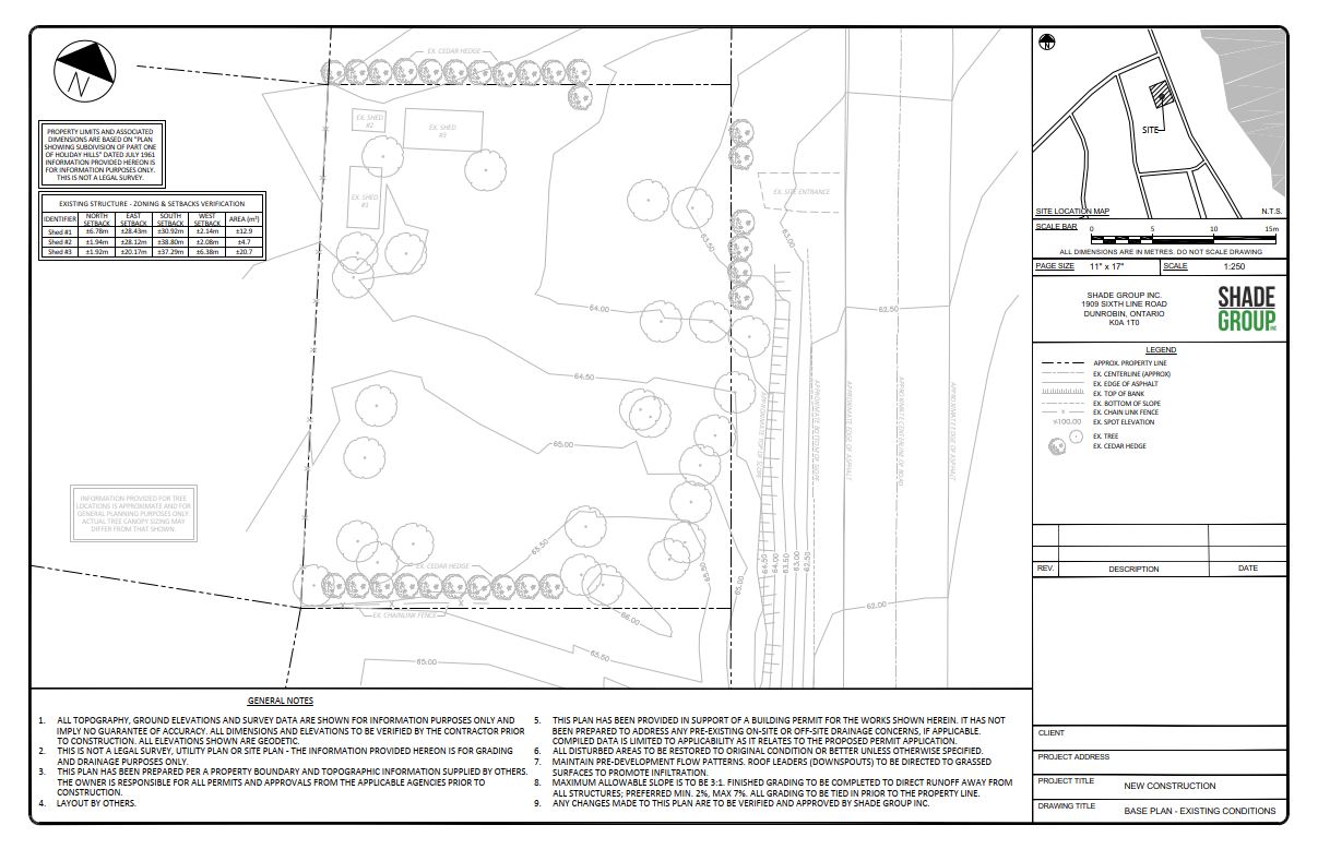
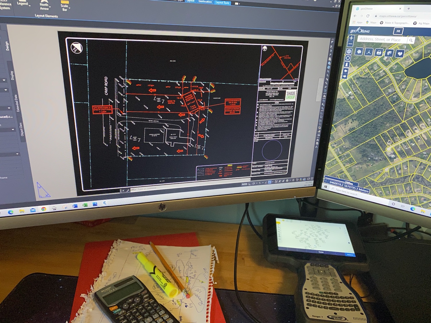
The second stage of a Grading and Drainage Plan design project involves processing the field data. Using AutoCAD drafting software, our staff compile the information collected in the field and use it to draw a sketch of your property. On this sketch will be all applicable site features like driveways, buildings, roads, fire hydrants, etc. This base plan shows the existing conditions of your property and is used as the jumping off point to developing the Grading Plan for your project.
Step #3. Preparing the Grading Plan
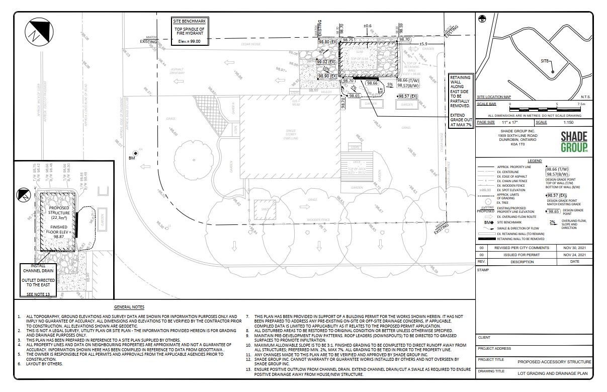
After the base plan has been prepared, we will work with you to develop a final grading plan that shows the proposed development; or compile our base plan data with an existing site plan. The final step is including all of the relevant construction details and design elevations on the Grading and Drainage Plan. These construction details focus primarily on ensuring that the proposed development does not negatively impact either the existing property or the surrounding properties from a grading and drainage perspective. If your property is located within a new subdivision, this may include reviewing the municipality’s approved plans for the subdivision as a whole, to ensure that the proposed project and the grading proposed, does not conflict with the previous approved plan. In subdivisions particularly, cohesion of the properties is important to ensure that the properties work together.
As-Builts for Grading Plans
The municipality may also ask for a post-construction or “as-built” plan. This is prepared after the completion of all construction which demonstrates what has actually been built. Similar to a building inspection, where an official comes to check on the project and ensure that what was built matches the plans, an as-built plan can be used to demonstrate that the grades and features proposed have been built as originally approved. This is particularly common on projects involving regulatory bodies in and around floodplains, as in these cases, construction below a floodplain elevation can lead to significant damage.
Similar to the preparation of a new plan, an as-built plan will require a field visit to collect topographic data. Alternatively, we can prepare a plan based on information supplied by your contractor. This data would then be compiled with the original approved Grading Plan, and shown as markups on a plan; highlighting any minor or major changes that occurred during construction. Finally, this plan would be submitted to the municipality for their approval and final sign off on your project.
If you have been asked to provide a Grading Plan or an As-Built Plan for your project, please fill out the Request an Estimate form and we’ll get right back to you. Note that we generally respond within 24-48 hours - so if you haven't received a response - check your junk mail!